
• Skip to primary navigation
  • Skip to main content
ARCI

ARCI

Avian Research and Conservation Institute

  • About
    • Our Approach and Mission
    • Staff and Colleagues
    • Media
  • Research
    • Programs
    • Tracking Studies
  • Blog
  • Get Involved
    • 2026 Kite Population Survey
    • Submit Bird Sightings
    • Monitor a Nest: Eyes on Kites
    • Follow us on Facebook
  • Donate
  • Show Search
Hide Search

A tracking first for Reddish Egrets

Ding #1 was fitted with a solar-powered, GPS-equipped satellite transmitter on 20 June 2014 at the J.N. Ding Darling National Wildlife Refuge on Sanibel Island, Florida.  For nearly a year, Ding #1’s movements centered on the bird’s foraging range on Sanibel Island, an area near the popular Wildlife Drive, with only occasional flights longer than five miles (See Ding #1’s animated tracking map).
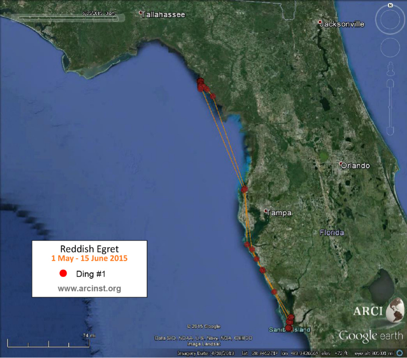

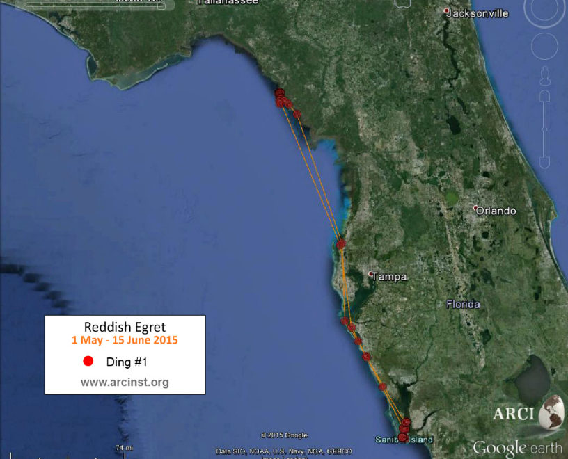
In early May of 2015, Ding #1 started to make day trips to Pine Island, and, within a week, moved into the shallows of Little Pine Island to the northeast. On 15 May 2015, Ding #1 started moving north, very far north. Ding #1’s tracking data shows the bird stayed overnight on Anna Maria Island, then continued up the Gulf coast for two days, finally settling into the Big Bend Wildlife Management Area just north of Steinhatchee, Florida, a total move of approximately 250 miles. 

Movements of Ding #1 showing the first-ever long-distance move of a Reddish Egret documented by satellite telemetry.
For 25 days, Ding #1 foraged along the remote tidal flats of the Tide Swamp Unit of the Big Bend Wildlife Management Area and each night flew five miles to the south to roost on an offshore island. On 9 June 2015 Ding left his morning roost and started a southbound track back to familiar ground near Pine Island. Ding #1 spent a night on an offshore island west of Pine Island and made his way back to the Wildlife Loop Drive near the observation tower the next morning.

Ding #1 with backpack transmitter
[photo credit: Jim Bennight]


This is the first documented long-distance seasonal movement (over 30 miles) of any Reddish Egret tracked in Florida. We are are eager to continue watching Ding #1’s data as this will help us continue to understand his month-long foray to Florida’s Nature Coast. This is an excellent example of the power of satellite telemetry to reveal the unseen lives of birds.   

July 6, 2015 by ARCI Leave a Comment

Filed Under: Uncategorized

Reader Interactions

Leave a Reply Cancel reply

Your email address will not be published. Required fields are marked *


The reCAPTCHA verification period has expired. Please reload the page.

Footer

Avian Research and Conservation Institute
1024 NE 9th Avenue
Gainesville, FL 32601
(352) 514-5606
A 501(c)(3) nonprofit

Copyright © 2026 · Log in

DATA-DRIVEN BIRD CONSERVATION

Contributions or gifts to Avian Research and Conservation Institute (ARCI), a 501(c)(3) organization, are deductible as charitable contributions for United States federal income tax purposes. 

  • Email
  • Facebook